A clandestine Soviet military base nestled inside a caldera formed by four volcanoes in the Kuril Islands might hold crucial clues to understanding past climate disasters and predicting future ones. The base, built during the Cold War on Matua Island, provided scientists a rare opportunity to study the geological history and volcanic activity of the region, offering insights into potentially catastrophic events that could impact the global climate.
Matua Island, strategically important due to its location near Japan, hosted a sophisticated Soviet military installation complete with bunkers, tunnels, and an airstrip. However, beneath this infrastructure lies a geological treasure trove. Scientists believe the volcanic activity on the island has left a detailed record of past eruptions and their climatic consequences, potentially providing a model for understanding the impact of large-scale volcanic events on the modern world. Recent expeditions to the island, involving researchers from Russia and beyond, have focused on analyzing volcanic deposits, studying gas emissions, and mapping the complex geological structures of the caldera. Their findings are expected to shed light on the magnitude and frequency of past eruptions, as well as the mechanisms by which volcanic eruptions can trigger significant climate shifts.
The research is particularly relevant given growing concerns about the potential for future “super-eruptions” or large-scale volcanic events that could dwarf historical eruptions like the Krakatoa eruption of 1883 or the Mount Tambora eruption of 1815, which caused the “Year Without a Summer.” Understanding the geological history of regions like Matua Island is essential for assessing the risk posed by such events and developing strategies to mitigate their impact. The Kuril Islands themselves are part of the Pacific Ring of Fire, a region known for its intense seismic and volcanic activity. The area is home to numerous active volcanoes, and the geological record indicates a history of powerful eruptions that have had far-reaching consequences.
The Soviet base on Matua Island, now abandoned, inadvertently created a unique research opportunity. The military presence limited access to the island for decades, preserving the geological record from extensive human disturbance. As a result, scientists can now study the volcanic landscape in a relatively pristine state, offering insights that would be difficult to obtain in more developed or heavily studied areas. The research expeditions face numerous challenges, including the remote location of the island, the difficult terrain, and the remnants of the former military base, which pose potential safety hazards. Despite these challenges, scientists are determined to unlock the secrets hidden within the volcanic landscape of Matua Island, recognizing the potential to advance our understanding of climate change and geological hazards. The insights gained from this research could inform policy decisions related to climate mitigation, disaster preparedness, and land-use planning in volcanically active regions around the world. Moreover, the study of Matua Island’s volcanic history may help refine climate models, allowing for more accurate predictions of future climate scenarios under different volcanic eruption scenarios.
The scientific community hopes that further research on Matua Island will continue to provide critical data, improving our understanding of the intricate relationship between volcanic activity and global climate. The combination of unique geological formations, historical preservation due to the Soviet military presence, and cutting-edge research methodologies makes Matua Island a crucial site for unraveling the mysteries of Earth’s past and preparing for its future.
Expanded Context and Further Details
Matua Island, a remote and rugged landmass in the Kuril Island chain, presents a compelling intersection of geopolitical history and geological significance. Its strategic location between Russia and Japan made it a focal point during World War II and later, the Cold War. The Soviet Union, recognizing its military potential, established a substantial base on the island, complete with an airfield capable of handling advanced aircraft, extensive underground bunkers, and a network of tunnels designed to withstand potential attacks. This infrastructure, now largely abandoned and decaying, provides a stark reminder of the island’s past as a military stronghold.
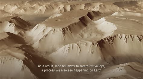
However, beneath the remnants of the Soviet base lies a geological story of immense importance. Matua Island is essentially a complex volcanic structure, a caldera formed by the overlapping activity of four distinct volcanoes. This unique geological setting has created a rich and detailed record of past volcanic eruptions, offering scientists a rare opportunity to study the long-term impact of these events on the Earth’s climate and environment. The volcanic deposits on the island, ranging from ash layers to lava flows, provide a chronological archive of past eruptions, allowing researchers to reconstruct the frequency, magnitude, and composition of these events.
The Kuril Islands are part of the Pacific Ring of Fire, a seismically and volcanically active region that encircles the Pacific Ocean. This region is responsible for a significant proportion of the world’s earthquakes and volcanic eruptions. The intense geological activity is driven by the movement of tectonic plates, with the Pacific Plate subducting beneath other plates along the margins of the ocean. The subduction process generates magma, which rises to the surface and fuels volcanic eruptions.
The volcanic activity in the Kuril Islands has shaped the landscape over millions of years, creating a chain of volcanic islands that stretch for over 1,200 kilometers. These islands are home to numerous active volcanoes, many of which have a history of explosive eruptions. The volcanic eruptions in the Kuril Islands have had a significant impact on the surrounding environment, both on land and in the ocean. The ash and gases released during eruptions can affect air quality, disrupt ecosystems, and even impact global climate.
The research on Matua Island is focused on understanding the relationship between volcanic eruptions and climate change. Large volcanic eruptions can inject significant amounts of sulfur dioxide into the stratosphere, where it reacts with water vapor to form sulfate aerosols. These aerosols reflect sunlight back into space, causing a temporary cooling of the Earth’s surface. The magnitude and duration of this cooling effect depend on the size of the eruption, the amount of sulfur dioxide injected into the stratosphere, and the atmospheric conditions.
The eruption of Mount Tambora in 1815 is a well-known example of a volcanic eruption that had a significant impact on global climate. The eruption injected a massive amount of sulfur dioxide into the stratosphere, leading to a period of global cooling known as the “Year Without a Summer” in 1816. In many parts of the world, crops failed, and there were widespread food shortages. The eruption of Mount Pinatubo in 1991 also had a measurable impact on global climate, causing a temporary cooling of about 0.5 degrees Celsius.
Scientists are particularly interested in studying the geological record on Matua Island to understand the potential impact of future “super-eruptions.” These are extremely large volcanic eruptions that release massive amounts of ash and gases into the atmosphere, potentially causing significant and long-lasting climate change. The Yellowstone Caldera in the United States is one example of a region that has experienced super-eruptions in the past, and scientists are closely monitoring the area for signs of future activity.
The research on Matua Island involves a variety of scientific techniques, including geological mapping, geochemical analysis, and remote sensing. Geologists are mapping the volcanic deposits on the island to understand the sequence of past eruptions and the processes that formed the volcanic landscape. Geochemical analysis is used to determine the composition of the volcanic rocks and ash, providing clues about the source of the magma and the conditions under which it erupted. Remote sensing techniques, such as satellite imagery and LiDAR, are used to create detailed maps of the island and to monitor volcanic activity.
One of the challenges of conducting research on Matua Island is its remote location and difficult terrain. The island is only accessible by boat, and the weather conditions can be unpredictable. The remnants of the Soviet military base also pose potential safety hazards, including unexploded ordnance and contaminated sites. Despite these challenges, scientists are committed to continuing their research on Matua Island, recognizing the importance of understanding the island’s volcanic history and its potential implications for global climate.
The insights gained from the research on Matua Island could inform policy decisions related to climate mitigation, disaster preparedness, and land-use planning in volcanically active regions around the world. By understanding the potential impact of volcanic eruptions on climate, scientists can help policymakers develop strategies to mitigate the risks and protect vulnerable populations. The study of Matua Island’s volcanic history may also help refine climate models, allowing for more accurate predictions of future climate scenarios under different volcanic eruption scenarios. The island serves as a natural laboratory, providing invaluable data for understanding complex Earth processes and their potential impact on the future of our planet.
The research team also faces logistical challenges, including securing funding, transporting equipment and personnel to the remote island, and dealing with the unpredictable weather conditions in the North Pacific. However, the potential rewards of the research outweigh the challenges, as the data collected from Matua Island could have significant implications for our understanding of climate change and volcanic hazards. Furthermore, the international collaboration involved in the research promotes scientific exchange and cooperation, fostering a global effort to address these critical issues.
The volcanic history of Matua Island is not only relevant to understanding past climate disasters but also to assessing the current volcanic hazards in the region. The Kuril Islands are a seismically active region, and future volcanic eruptions are inevitable. By studying the past eruptive behavior of the volcanoes on Matua Island, scientists can better assess the potential risks posed by future eruptions and develop strategies to mitigate their impact. This includes developing early warning systems, improving evacuation plans, and educating the public about volcanic hazards.
Moreover, the research on Matua Island can contribute to our understanding of the broader geological processes that shape the Earth’s surface. Volcanic activity plays a crucial role in the formation of new landmasses, the cycling of elements between the Earth’s interior and its surface, and the evolution of the atmosphere and oceans. By studying the volcanic landscape of Matua Island, scientists can gain insights into these fundamental processes and their impact on the planet’s environment.
The discovery of the Soviet military base on Matua Island added another layer of complexity to the research. The base’s presence for several decades has had both positive and negative effects on the island’s environment. On the one hand, the military restricted access to the island, which helped preserve its natural landscape and geological features. On the other hand, the military activities have also resulted in some environmental damage, including soil contamination and the introduction of invasive species.
The research team is working to assess the environmental impact of the Soviet military base and to develop strategies for remediation and restoration. This includes removing hazardous materials, cleaning up contaminated sites, and controlling invasive species. The goal is to restore the island’s natural environment and to protect its unique geological features for future generations.
The legacy of the Soviet base also presents unique challenges for the research team. The presence of abandoned buildings, tunnels, and equipment can pose safety hazards, and the team must take precautions to avoid accidents. Additionally, the team must navigate the complex bureaucratic processes involved in gaining access to the island and conducting research in a former military zone.
Despite these challenges, the research team is committed to uncovering the secrets of Matua Island and to sharing their findings with the scientific community and the public. The research is a testament to the power of scientific collaboration and the importance of understanding the Earth’s past to prepare for its future. The combination of historical context, unique geological formations, and dedicated scientific investigation makes Matua Island a crucial site for unraveling the mysteries of our planet.
The future research plans for Matua Island include more detailed geological mapping, advanced geochemical analysis, and the use of drones and other remote sensing technologies to monitor volcanic activity. The team also plans to conduct further studies of the island’s ecosystem to understand the impact of volcanic eruptions on plant and animal life.
Ultimately, the goal of the research on Matua Island is to provide a comprehensive understanding of the island’s volcanic history and its potential implications for global climate and volcanic hazards. The findings will be used to inform policy decisions, improve disaster preparedness, and educate the public about the importance of understanding our planet’s dynamic processes. The story of Matua Island is a reminder of the interconnectedness of geological, environmental, and human history, and the importance of scientific research in addressing the challenges facing our world.
The unique convergence of factors – the island’s volcanic activity, strategic military past, and relative isolation – makes Matua Island an exceptional location for scientific inquiry. The research being conducted there exemplifies how understanding Earth’s past can provide critical insights into its future, helping humanity prepare for the challenges posed by climate change and natural disasters.
Frequently Asked Questions (FAQ)
-
What makes Matua Island so important for climate research?
- Matua Island, part of the Kuril Islands, is a caldera formed by four volcanoes with a well-preserved geological record of past eruptions. The Soviet military base inadvertently protected this record, offering scientists a unique opportunity to study the link between volcanic activity and climate change. The analysis of volcanic deposits can provide insights into the magnitude and frequency of past eruptions and their climatic consequences.
-
How did the Soviet military presence affect the research potential of Matua Island?
- The Soviet military base limited access to the island for decades, preserving the geological record from extensive human disturbance. Although the base also caused some environmental damage, the overall preservation of the volcanic landscape allows scientists to study it in a relatively pristine state, offering insights that would be difficult to obtain elsewhere.
-
What are some of the challenges of conducting research on Matua Island?
- The challenges include the island’s remote location, difficult terrain, unpredictable weather conditions, and the potential safety hazards posed by the remnants of the former Soviet military base, such as unexploded ordnance and contaminated sites. Logistical challenges also include securing funding and transporting equipment.
-
What are “super-eruptions,” and why are scientists studying Matua Island in relation to them?
- “Super-eruptions” are extremely large volcanic eruptions that release massive amounts of ash and gases into the atmosphere, potentially causing significant and long-lasting climate change. Scientists are studying the geological record on Matua Island to understand the potential impact of future super-eruptions, as past volcanic activity provides a model for understanding the consequences of such events.
-
What kind of scientific techniques are being used on Matua Island?
- Researchers are using a variety of techniques, including geological mapping to understand the sequence of past eruptions, geochemical analysis to determine the composition of volcanic materials, and remote sensing technologies such as satellite imagery and LiDAR to monitor volcanic activity and create detailed maps of the island.