")


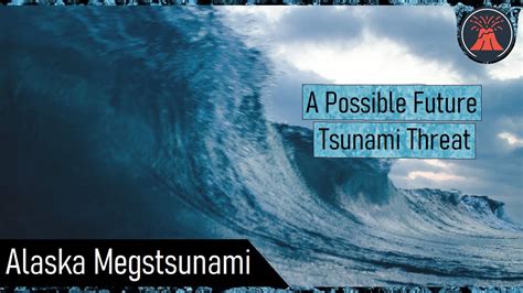
A potential mega-tsunami, triggered by a massive landslide in the Canary Islands, could unleash a 1,000-foot wave capable of devastating coastlines across the Atlantic, scientists warn, highlighting the need for enhanced monitoring and preparedness.
Scientists are raising concerns about the possibility of a mega-tsunami generated by a landslide on the Cumbre Vieja volcano on La Palma, in the Canary Islands, potentially sending a 1,000-foot (305-meter) wave across the Atlantic Ocean. While experts debate the likelihood and scale of such an event, research indicates the risk, albeit potentially low in probability, warrants serious consideration and preparedness measures. The source of this renewed concern stems from ongoing geological activity on La Palma and theoretical models simulating the effects of a large-scale landslide into the ocean.
The possibility of a mega-tsunami originating from the Canary Islands has been a topic of scientific discussion for decades. Concerns were heightened following volcanic activity on La Palma, which prompted investigations into the stability of the island’s western flank. Past research has suggested that a significant portion of the island could potentially collapse into the ocean, triggering a wave far larger than those typically associated with earthquakes.
“A sufficiently large landslide on La Palma could indeed generate a tsunami that propagates across the Atlantic,” explained Dr. Simon Day, a researcher at University College London who has extensively studied the potential for mega-tsunamis in the Canary Islands. “The exact size and impact of such a tsunami would depend on the volume and velocity of the landslide, as well as the geometry of the ocean basin.”
The primary threat stems from the unstable western flank of Cumbre Vieja. Scientists believe that a future eruption could destabilize this section of the volcano, leading to a massive landslide. The sheer volume of rock and debris entering the ocean rapidly could displace a tremendous amount of water, initiating a mega-tsunami.
Although the probability of such an event occurring in the near future is debated, the potential consequences are severe. Computer simulations have suggested that a mega-tsunami generated by a La Palma landslide could reach coastlines in North America, South America, and Europe. While the wave would diminish in size as it travels across the ocean, it could still cause significant damage and inundation in coastal areas.
“The scale of destruction would depend on several factors, including the size of the initial wave, the shape of the coastline, and the level of preparedness,” stated Dr. Bill McGuire, an Emeritus Professor of Geophysical and Climate Hazards at University College London. “Even a relatively small mega-tsunami could overwhelm coastal defenses and cause widespread damage.”
The most vulnerable regions include the eastern seaboard of the United States, the Caribbean islands, and coastal areas in Europe, particularly Portugal, Spain, and the United Kingdom. The impact on these regions would vary depending on their proximity to the source and their coastal topography. Low-lying areas and those with gently sloping coastlines would be particularly susceptible to inundation.
While the scientific community agrees on the potential for a La Palma-generated mega-tsunami, there is considerable debate regarding the likelihood of such an event. Some researchers believe that the risk is relatively low, arguing that the volcano is unlikely to experience a landslide of sufficient magnitude to generate a mega-tsunami. Others contend that the risk is more significant, particularly given the ongoing volcanic activity on La Palma and the potential for future eruptions.
“It is important to emphasize that we are not predicting an imminent mega-tsunami,” clarified Dr. Day. “However, the possibility exists, and it is crucial to understand the potential consequences so that we can prepare accordingly.”
Preparedness measures include developing tsunami warning systems, creating evacuation plans, and strengthening coastal infrastructure. Public education is also essential to ensure that communities understand the risks and know how to respond in the event of a tsunami warning.
“Education is key,” stressed Dr. McGuire. “People need to be aware of the potential dangers and know what to do if a tsunami is approaching. This includes knowing the evacuation routes, identifying safe zones, and having an emergency plan in place.”
Investing in early warning systems is another critical aspect of preparedness. These systems use sensors to detect tsunamis and provide timely warnings to coastal communities. The sooner a warning is issued, the more time people have to evacuate and take other protective measures.
“Early warning systems are essential for saving lives,” emphasized Dr. Day. “They provide crucial lead time that allows people to move to safety before the tsunami arrives.”
Strengthening coastal infrastructure is also vital to mitigate the impact of a mega-tsunami. This includes building seawalls, reinforcing buildings, and elevating infrastructure above potential inundation levels.
“Investing in coastal protection measures can significantly reduce the damage caused by a tsunami,” explained Dr. McGuire. “While it is impossible to eliminate all risk, these measures can help to protect lives and property.”
The debate surrounding the La Palma mega-tsunami highlights the importance of ongoing research and monitoring. Scientists continue to study the volcano and its surrounding environment to better understand the potential for future landslides and tsunamis. This research is essential for refining risk assessments and developing effective preparedness measures.
“We need to continue to monitor La Palma and other volcanic islands to better understand the potential for landslides and tsunamis,” stated Dr. Day. “This research is crucial for protecting coastal communities around the world.”
The potential for a mega-tsunami from La Palma serves as a reminder of the power of natural disasters and the importance of being prepared. While the probability of such an event is uncertain, the consequences could be catastrophic. By investing in research, early warning systems, coastal protection measures, and public education, we can significantly reduce the risk and protect vulnerable communities.
The Canary Islands, including La Palma, are located in a volcanically active region. The islands were formed by volcanic activity over millions of years, and eruptions are relatively common. The Cumbre Vieja volcano, which is located on the southern part of La Palma, has been particularly active in recent centuries.
The most recent eruption of Cumbre Vieja began in September 2021 and lasted for 85 days. The eruption caused significant damage to infrastructure and homes, and thousands of people were evacuated. The eruption also raised concerns about the stability of the western flank of the volcano.
The geological structure of La Palma is complex, with layers of volcanic rock and ash. The western flank of Cumbre Vieja is believed to be particularly unstable due to a combination of factors, including the presence of fractures and faults, the accumulation of volcanic debris, and the influence of groundwater.
A major landslide on the western flank of Cumbre Vieja could displace a massive amount of water, generating a mega-tsunami. Computer simulations have suggested that such a tsunami could reach heights of hundreds of feet near the source and could still be several feet high when it reaches distant coastlines.
The impact of a mega-tsunami would depend on several factors, including the size of the wave, the shape of the coastline, and the level of preparedness. Low-lying areas and those with gently sloping coastlines would be particularly vulnerable to inundation.
The potential consequences of a La Palma mega-tsunami are significant. In addition to the immediate loss of life and property, a mega-tsunami could also cause long-term economic and environmental damage. It could disrupt trade and transportation, damage infrastructure, and contaminate water supplies.
Preparing for a mega-tsunami is a complex and challenging task. It requires a combination of research, monitoring, early warning systems, coastal protection measures, and public education. It also requires international cooperation, as a mega-tsunami could impact multiple countries.
The scientific community is working to better understand the potential for mega-tsunamis and to develop effective preparedness measures. This includes conducting research on volcanic activity, developing computer models to simulate tsunami propagation, and designing early warning systems.
Governments and communities around the world are also taking steps to prepare for tsunamis. This includes developing evacuation plans, building seawalls, and educating the public about tsunami safety.
While it is impossible to eliminate all risk, these efforts can help to reduce the impact of a mega-tsunami and protect vulnerable communities. The ongoing research and preparedness efforts are essential for ensuring the safety and resilience of coastal communities in the face of this potential threat.
The debate surrounding the potential mega-tsunami from La Palma also underscores the broader challenges of managing natural disaster risks. Climate change is exacerbating many natural hazards, including sea level rise, extreme weather events, and wildfires. These hazards pose a growing threat to communities around the world, and it is essential to invest in mitigation and adaptation measures.
Mitigation involves reducing greenhouse gas emissions to slow down climate change. This requires a global effort to transition to cleaner energy sources and reduce deforestation. Adaptation involves taking steps to protect communities from the impacts of climate change. This includes building seawalls, developing drought-resistant crops, and improving emergency response systems.
Managing natural disaster risks also requires a focus on social equity. Vulnerable communities are often disproportionately affected by natural disasters, and it is essential to ensure that these communities have the resources and support they need to prepare for and recover from disasters. This includes providing access to affordable housing, healthcare, and education.
The challenges of managing natural disaster risks are significant, but they are not insurmountable. By working together, we can reduce the risks and protect vulnerable communities. The ongoing research and preparedness efforts related to the La Palma mega-tsunami are a reminder of the importance of this work.
In conclusion, the potential for a mega-tsunami originating from a landslide on La Palma is a serious concern that warrants careful attention. While the probability of such an event occurring in the near future is debated, the potential consequences are severe. By investing in research, early warning systems, coastal protection measures, and public education, we can significantly reduce the risk and protect vulnerable communities. This requires a collaborative effort involving scientists, governments, communities, and individuals. It also requires a commitment to addressing the broader challenges of managing natural disaster risks in a changing climate. The lessons learned from the La Palma mega-tsunami debate can help us to better prepare for other natural hazards and build more resilient communities. The constant monitoring and simulations are paramount in staying ahead of potential catastrophic events.
FAQ: Mega-Tsunami from La Palma
-
What is a mega-tsunami and how is it different from a regular tsunami? A mega-tsunami is a tsunami with an initial wave height much larger than a typical tsunami. Regular tsunamis are usually caused by underwater earthquakes, whereas mega-tsunamis are typically triggered by massive landslides, volcanic eruptions, or asteroid impacts into the ocean. This creates a much larger initial displacement of water, leading to a significantly bigger and more destructive wave. While regular tsunamis might have wave heights of a few meters, mega-tsunamis can have initial wave heights of hundreds of meters.
-
What is the specific cause of concern regarding a mega-tsunami from La Palma? The primary concern stems from the unstable western flank of the Cumbre Vieja volcano on the island of La Palma in the Canary Islands. Scientists believe that a future eruption could destabilize this section of the volcano, leading to a massive landslide into the Atlantic Ocean. The sudden displacement of a large volume of rock and debris into the water could generate a mega-tsunami.
-
How likely is a mega-tsunami from La Palma, and when could it potentially occur? The likelihood of a mega-tsunami from La Palma is a subject of ongoing debate within the scientific community. While most scientists agree that the potential exists, the probability of a large-scale landslide occurring in the near future is uncertain. There is no consensus on when such an event might occur. Some researchers believe the risk is relatively low, while others contend that it is more significant, particularly given the ongoing volcanic activity on the island. It is important to note that even if the probability is low, the potential consequences warrant preparedness measures.
-
Which regions are most at risk from a La Palma mega-tsunami, and what level of damage could they expect? The regions most at risk include the eastern seaboard of the United States, the Caribbean islands, and coastal areas in Europe, particularly Portugal, Spain, and the United Kingdom. The level of damage would depend on several factors, including the size of the initial wave, the shape of the coastline, and the level of preparedness. Low-lying areas and those with gently sloping coastlines would be particularly susceptible to inundation. A mega-tsunami could cause widespread destruction, including loss of life, damage to infrastructure, and economic disruption.
-
What measures are being taken to prepare for a potential mega-tsunami from La Palma, and what can individuals do to protect themselves? Preparedness measures include:
- Developing tsunami warning systems: These systems use sensors to detect tsunamis and provide timely warnings to coastal communities.
- Creating evacuation plans: These plans outline evacuation routes and safe zones for coastal communities.
- Strengthening coastal infrastructure: This includes building seawalls, reinforcing buildings, and elevating infrastructure above potential inundation levels.
- Public education: Educating the public about the risks of tsunamis and what to do in the event of a warning.
Individuals can protect themselves by:
*   Knowing the tsunami warning signs (e.g., a sudden rise or fall in sea level).
*   Familiarizing themselves with evacuation routes and safe zones.
*   Having an emergency plan in place.
*   Following the instructions of local authorities in the event of a tsunami warning.
* Staying informed about the latest developments and potential risks.- What factors contribute to the instability of the Cumbre Vieja volcano’s western flank?
Several factors contribute to the instability, making it prone to landslides. These include:
- Volcanic Activity: Ongoing volcanic eruptions and seismic activity can weaken the structure of the rock. The heat and pressure from eruptions can cause fracturing and destabilization.
- Geological Structure: The composition of the volcano, which includes layers of porous volcanic rock and ash, is prone to saturation by water. This increases the weight and reduces the structural integrity of the flank.
- Faults and Fractures: The presence of pre-existing faults and fractures within the rock mass further weakens the structure and creates potential slip planes.
- Gravity: The sheer mass of the western flank exerts a constant gravitational force, increasing the stress on the unstable sections.
- Hydrothermal Alteration: The alteration of rocks by hot, chemically active fluids can weaken them over time, making them more susceptible to collapse.
- How do scientists model the potential impact of a mega-tsunami originating from La Palma?
Scientists use sophisticated computer models to simulate tsunami propagation and its potential impact on coastal regions. These models incorporate various factors, including:
- Landslide Parameters: The volume, velocity, and shape of the potential landslide.
- Ocean Bathymetry: The depth and shape of the ocean floor, which influences the speed and direction of tsunami waves.
- Coastal Topography: The shape and elevation of the coastline, which determines the extent of inundation.
- Fluid Dynamics: The complex interaction of water movement during the tsunami event.
These models allow scientists to estimate the wave height, arrival time, and inundation extent for different coastal locations, providing valuable information for risk assessment and preparedness planning.
- What international collaborations are in place to monitor and respond to potential mega-tsunami threats?
Several international collaborations are in place to monitor and respond to potential tsunami threats, including:
- UNESCO’s Intergovernmental Oceanographic Commission (IOC): The IOC coordinates the development and implementation of tsunami warning systems worldwide.
- The Pacific Tsunami Warning System (PTWS): A network of seismic and sea-level sensors that monitors the Pacific Ocean for tsunamis.
- The Indian Ocean Tsunami Warning and Mitigation System (IOTWS): A similar system for the Indian Ocean, established after the devastating 2004 tsunami.
- European Union Civil Protection Mechanism: Facilitates cooperation in disaster response among participating states.
- Scientific Research Collaborations: International teams of scientists collaborate on research projects to improve our understanding of tsunami generation, propagation, and impact.
- How has the 2021 eruption of Cumbre Vieja affected the assessment of mega-tsunami risk?
The 2021 eruption of Cumbre Vieja has heightened concerns about the stability of the volcano’s western flank. While the eruption did not trigger a major landslide, it served as a reminder of the volcano’s activity and the potential for future eruptions. The eruption may have further weakened the rock mass on the western flank, increasing the risk of a future landslide. However, it also provided valuable data for scientists to refine their models and risk assessments. Detailed monitoring of the volcano’s structure and ongoing activity is crucial in reassessing the mega-tsunami risk.
- Beyond mega-tsunamis, what other natural hazards threaten the Canary Islands and similar volcanic island environments?
Besides mega-tsunamis, other significant natural hazards in the Canary Islands and similar volcanic island environments include:
- Volcanic Eruptions: Eruptions can cause lava flows, ashfall, pyroclastic flows, and volcanic gas emissions, all of which can pose serious threats to human health and infrastructure.
- Earthquakes: Volcanic activity is often accompanied by earthquakes, which can cause damage to buildings and infrastructure.
- Landslides and Debris Flows: Heavy rainfall and volcanic activity can trigger landslides and debris flows, which can bury homes and infrastructure.
- Coastal Erosion: The islands are vulnerable to coastal erosion due to wave action and sea-level rise.
- Extreme Weather Events: The islands can experience heavy rainfall, strong winds, and heatwaves, which can cause damage and disruption.
- Wildfires: Dry vegetation and strong winds can create conditions conducive to wildfires, which can threaten homes and natural areas.
- What role does sea level rise play in exacerbating the potential impacts of a mega-tsunami?
Sea level rise significantly exacerbates the potential impacts of a mega-tsunami. Higher sea levels mean that a tsunami wave will inundate further inland, affecting a larger area and population. Coastal defenses, such as seawalls, may become less effective as sea levels rise, leaving communities more vulnerable. Sea level rise also increases the frequency and severity of coastal flooding, making it more difficult for communities to recover from a mega-tsunami. The combination of sea level rise and a mega-tsunami could have catastrophic consequences for coastal regions.
- Are there any historical precedents for mega-tsunamis caused by volcanic island collapses?
Yes, there are several historical precedents for mega-tsunamis caused by volcanic island collapses. One notable example is the 1792 Unzen earthquake and volcanic eruption in Japan, which triggered a massive landslide into the sea, generating a tsunami that killed approximately 15,000 people. Another example is the 1883 eruption of Krakatoa in Indonesia, which caused a volcanic island to collapse, generating a series of tsunamis that killed over 36,000 people. These historical events demonstrate the devastating potential of mega-tsunamis caused by volcanic island collapses.
- How can building codes and urban planning be adapted to reduce the vulnerability of coastal communities to mega-tsunamis?
Building codes and urban planning can be adapted in several ways to reduce vulnerability:
- Elevated Construction: Requiring new buildings in vulnerable areas to be elevated above the potential inundation level.
- Reinforced Structures: Mandating the use of reinforced concrete and other resilient materials to withstand the force of a tsunami wave.
- Setback Distances: Establishing setback distances from the coastline to prevent construction in the most vulnerable areas.
- Land Use Planning: Designating certain areas for parks and open spaces to act as buffer zones between the coastline and populated areas.
- Evacuation Routes: Designing and maintaining clear evacuation routes to allow people to reach safe zones quickly.
- Critical Infrastructure Protection: Protecting critical infrastructure, such as hospitals and power plants, from tsunami damage.
- What are the psychological impacts of living in a region threatened by a potential mega-tsunami, and how can these impacts be addressed?
Living under the threat of a mega-tsunami can lead to chronic stress, anxiety, and fear. Individuals may experience sleep disturbances, difficulty concentrating, and feelings of helplessness. Communities may also suffer from social disruption and economic uncertainty. Addressing these impacts requires a multi-faceted approach:
- Mental Health Services: Providing access to mental health professionals who can offer counseling and support.
- Community Education: Educating the public about the risks of tsunamis and the measures that can be taken to protect themselves.
- Participatory Planning: Involving communities in the development of evacuation plans and other preparedness measures.
- Risk Communication: Providing clear and timely information about potential threats.
- Building Resilience: Promoting social cohesion and community support networks to help people cope with stress and trauma.
- What technological advancements are being used to improve tsunami detection and warning systems?
Several technological advancements are improving tsunami detection and warning:
- Deep-ocean Assessment and Reporting of Tsunamis (DART) buoys: These buoys detect changes in sea level caused by tsunamis and transmit data to warning centers.
- Coastal Sea-Level Sensors: Coastal tide gauges and other sea-level sensors provide real-time data on wave activity.
- High-Resolution Bathymetry: Detailed maps of the ocean floor help scientists to model tsunami propagation more accurately.
- Satellite Altimetry: Satellites measure sea surface height, providing additional data for tsunami detection and monitoring.
- Advanced Computer Models: Sophisticated computer models simulate tsunami generation, propagation, and inundation, allowing scientists to forecast the potential impact of a tsunami.
- Improved Communication Systems: Reliable communication systems are essential for disseminating tsunami warnings to coastal communities quickly and effectively.
- Artificial Intelligence (AI): AI and machine learning techniques are being used to analyze data from various sources and improve the accuracy and speed of tsunami detection and forecasting.